What you can see on the Kanlaon cams
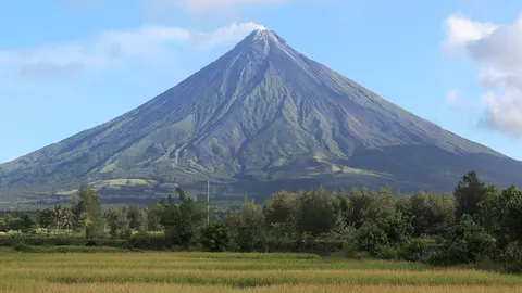
The livestream faces the summit. Most of the time it shows a plume of steam and gas from the crater, which can turn grey with ash during eruptions. Clouds cover the top of the mountain much of the day.
The forested slopes of Kanlaon under the clouds
This 4K livestream looks up at Kanlaon, the highest mountain on the island of Negros, across green farmland and forest. The volcano's long, dark slopes climb from the bottom of the frame to a summit that is often caught in cloud, and banks of cumulus drift across its flanks through the morning; a palm or tree fern edges the lower right corner.
Kanlaon is one of the most active volcanoes in the Philippines, and its crater can send up steam and ash with little warning. The early hours give the best chance of a clear summit before the clouds build.
Recent eruptions
Kanlaon erupted explosively in June 2024 and again in December 2024, sending ash columns several kilometres high and pyroclastic flows down its flanks. PHIVOLCS raised the alert level and thousands of people were evacuated from towns on its slopes; ash fell across Negros and nearby islands. The activity box on this page shows the latest weekly report.
When to watch Kanlaon
Early morning is the most likely time for a clear summit. The Philippines is eight hours ahead of UTC.
Around Kanlaon
The volcano rises between the two provinces of Negros Island, with sugarcane fields spreading across the lowlands. Canlaon City lies on its eastern slope, and Bacolod, the capital of Negros Occidental, is known for its MassKara Festival. Mount Kanlaon Natural Park protects the forests on the upper slopes, and its trails close whenever the volcano becomes restless.
Visiting Kanlaon
When the volcano is quiet, guided climbs start from the towns on its slopes and need permits from the park authorities. Whenever PHIVOLCS raises the alert level, the trails close and a danger zone around the summit applies.