What you can see on the Eldfell and Heimaey cams
The live videos look over the harbour and the town. The red cone of Eldfell and the older Helgafell rise behind the houses, while the cliff of Heimaklettur guards the harbour entrance. Fishing boats come and go, and on stormy days waves break against the cliffs.
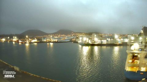
Eldfell and Helgafell above the harbour
From the shipyard on Heimaey, the camera looks across the harbour to the town spread along the far quays. Passenger boats and fishing vessels lie at the piers, with warehouses and fish plants behind them, and the bow of a large ship moored close by fills the right edge of the frame. Above the rooftops rise two volcanic cones, Eldfell and the older Helgafell, their bare reddish-brown slopes standing out against the sky.
This view sums up the eruption of 1973: the cone that grew in five months stands right behind the harbour its lava crept towards. Workers pumped seawater onto the flow to slow it, and the harbour survived.
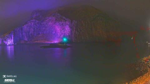
The great cliff of Heimaklettur over the harbour
The camera looks across the harbour water at Heimaklettur, the tall cliff that guards the harbour entrance on Heimaey. Its sheer face of layered rock, streaked with ochre and brown, drops straight to the water, and a grassy slope covers the top. In the middle of the frame a low breakwater ends in a small beacon, the rocky shore edges the lower right corner, and more cliffs rise further back on the right.
Unlike the other Heimaey cameras, this one leaves out the town and the volcanoes and keeps to rock and sea. Low sun turns the cliff orange and gold. The Westman Islands hold one of the largest puffin colonies in the world.
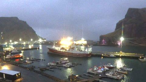
Trawlers and small boats in the fishing harbour
This wide, panoramic view looks over the fishing harbour of Heimaey from the town side. Small boats lie at floating pontoons in the foreground, a red-hulled trawler is moored at the quay beyond them, and storage tanks, silos and fish plants line the waterfront on both sides. Steep green and brown mountains close the view on the left, the massive cliff of Heimaklettur fills the right, and in the gap between them the sea shows on the horizon.
This is the working heart of the island. On the night the eruption began in January 1973, the fishing fleet was in port because of a storm, and it carried almost all the islanders to the mainland.
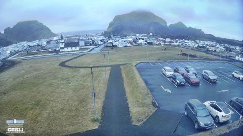
The rooftops of Heimaey and the mountains behind
From the grounds of the town's upper secondary school, the camera looks over a wide lawn, a footpath and a car park to the rooftops of Heimaey. A white church with a dark roof and steeple stands on the left, and streets of low houses spread out towards the harbour. Behind them rise the island's steep mountains: a rounded crag on the left, a massive cliff-faced rock in the centre and a jagged ridge to its right, with a glimpse of the sea on the left horizon.
This is the camera that shows the town itself, the only one on the only inhabited island of the Westman Islands. About 400 of its houses were buried by the lava and ash of 1973.
The 1973 eruption
The eruption began on 23 January 1973. Almost all of the island’s roughly 5,000 people were taken to the mainland that night by the fishing fleet, which happened to be in port because of a storm. Lava and ash buried about 400 houses, and as the lava crept towards the harbour, workers pumped seawater onto the front of the flow to cool and slow it down. The harbour survived, and the new lava even left it better sheltered than before. The eruption ended in July.
When to watch Eldfell and Heimaey
The islands are among the windiest places in Iceland; calm, clear days show the cones and cliffs at their best. Iceland is on UTC all year.
Around Heimaey
The Eldheimar museum displays a house dug out from the ash of 1973. The Westman Islands are home to one of the largest puffin colonies in the world. Offshore lies Surtsey, an island born from the sea in an eruption between 1963 and 1967, now a UNESCO World Heritage site closed to visitors.
Visiting Eldfell and Heimaey
Ferries sail to Heimaey from Landeyjahöfn on the south coast, a crossing of about 35 minutes, and there are also flights from Reykjavík. A path climbs to the top of Eldfell, where the ground is still warm in places.