Nature Live Cams

Mount Haku live cam

No recent report Stratovolcano in Ishikawa, Japan

Live image of Mount Haku: Shiramine village

Shiramine village

Source: Japan Meteorological Agency (JMA)

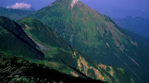
From the village of Shiramine in the valley, with the summit ridge and its snowfields above. What you see

Mount Haku, or Hakusan, is a 2,702 m (8,865 ft) stratovolcano on the border of Ishikawa and Gifu, close to the Sea of Japan coast. Together with Mount Fuji and Mount Tateyama it makes up the Three Holy Mountains of Japan, and it has been climbed by pilgrims since the eighth century.

Mount Haku right now

Activity

No recent report

No automatic alert feed for this volcano. The observatory links below carry the latest reports.

Local time

–

Sunrise at 6:19 am, in 7 h 6 min.

Clouds over the summit

Overcast

100% cloud cover. Clearest in the next 24 hours: around 11:00 am (16%).

At the summit

0 °C (32 °F)

Wind 6 km/h (4 mph) from the S.

Forecast model values for the summit area from MET Norway, updated 13:32 UTC. Not a measurement.

Is Mount Haku erupting right now?

No eruption reported. Nothing has been reported for it in recent weekly volcanic activity reports from the Smithsonian and USGS. Checked November 4, 14:02 UTC.

When did Mount Haku last erupt?

Last eruption: 1659.

Earthquakes near Mount Haku

No earthquakes large enough to appear in the international catalogue have been recorded within 30 km (19 mi) of the summit in the last 30 days.

Source: EMSC. Updated November 4, 13:02 UTC. EMSC combines the catalogues of national seismic networks, but it mostly lists earthquakes large enough to be reported internationally; many small volcanic earthquakes are not included. Small earthquakes are common under active volcanoes and do not by themselves mean an eruption is coming.

What you can see on the Haku cam

Hakusan is a long summit ridge above forested slopes, and the interest is the snow: the mountain sits in one of the snowiest regions on earth, and the snow line creeps down through autumn and retreats again in early summer. Mornings often show the ridge through haze as a soft grey outline, and autumn turns the lower slopes gold while the summit is already white.

The long summit ridge from the valley

From Shiramine, a village in the valley below, the camera looks up at the summit ridge of Mount Haku over a forested slope on the left. The ridge runs across the middle of the frame: a broad, rounded top on the left, a sharper rocky knob to its right, and a long crest continuing towards the right edge. In the morning the mountain is often seen through haze, as a soft grey outline.

Hakusan, 2,702 m high, lies in one of the snowiest regions on earth, and the snow line is the main thing to follow here: it creeps down these slopes through autumn and retreats again in early summer.

Snow, water and a thousand-year record

The name means «white mountain», and it is literal. Moist air off the Sea of Japan hits this first high ground and unloads, burying the valleys for months. That snow feeds the Tedori, Kuzuryū and Nagara rivers, which is why the mountain was worshipped by farmers downstream long before it became a hiking destination. The monk Taichō is said to have made the first ascent in 717. Eruptions were written down from the Heian period until the seventeenth century, all of them steam-driven explosions from craters near the top, and the last was in 1659. A debris avalanche came down the eastern flank in the middle of the Holocene, long before any of that.

When to watch Haku

Clear winter mornings show the ridge at its best, white against a low sun. Summer afternoons cloud over early. Autumn turns the foothills gold while the summit is already white. Japan is nine hours ahead of UTC.

Around Hakusan

Shiramine is known for steep-roofed houses built to shed snow, and for its hot springs. The Hakusan Shirakawa-gō White Road climbs towards the historic farmhouses of Shirakawa-gō, a short drive north.

Visiting Hakusan

The usual route starts at Bettōdeai and takes two days with a night at the Murodō mountain hut, which opens from early May to mid-October. Outside that window the mountain is a serious winter climb.
Volcano cams near Mount Haku

Mount Haku on the map

Mount Aso, Kumamoto, JapanAsoMount Fuji, Shizuoka and Yamanashi, JapanFujiMount Asama, Nagano and Gunma, JapanAsamaKirishima (Shinmoedake), Kagoshima and Miyazaki, JapanKirishimaKusatsu-Shirane, Gunma, JapanKusatsu-ShiraneMount Unzen, Nagasaki, JapanUnzenMount Tokachi, Hokkaido, JapanTokachiMount Iwate, Iwate, JapanIwateMount Hakkōda, Aomori, JapanHakkōdaMount Adatara, Fukushima, JapanAdataraMount Komagatake, Hokkaido, JapanKomagatakeMount Esan, Hokkaido, JapanEsanMount Zaō, Yamagata and Miyagi, JapanZaōMount Usu, Hokkaido, JapanUsuMount Bandai, Fukushima, JapanBandaiTaisetsuzan, Hokkaido, JapanTaisetsuzanKuttara, Hokkaido, JapanKuttaraAogashima, Izu Islands, Tokyo, JapanAogashimaMount Meakan, Hokkaido, JapanMeakanSatsuma-Iōjima, Kagoshima, JapanSatsuma-IōjimaAkita-Yakeyama, Akita, JapanAkita-YakeyamaAtosanupuri, Hokkaido, JapanAtosanupuriMount Chōkai, Akita and Yamagata, JapanChōkaiHachijōjima, Izu Islands, Tokyo, JapanHachijōjimaKuchinoerabujima, Kagoshima, JapanKuchinoerabujimaMount Kurikoma, Iwate, Miyagi and Akita, JapanKurikomaNakanoshima, Tokara Islands, Kagoshima, JapanNakanoshimaMount Nasu, Tochigi, JapanNasuMount Azuma, Fukushima, JapanAzumaMount Hakone, Kanagawa, JapanHakoneMount Haku, Ishikawa, JapanHakuMount Iwaki, Aomori, JapanIwakiIzu Ōshima, Tokyo, JapanIzu ŌshimaIzu-Tōbu, Shizuoka, JapanIzu-TōbuKōzushima, Tokyo, JapanKōzushimaMount Kujū, Oita, JapanKujūNiigata-Yakeyama, Niigata, JapanNiigata-YakeyamaNiijima, Tokyo, JapanNiijimaMount Nikkō-Shirane, Tochigi, JapanNikkō-ShiraneMount Norikura, Nagano, JapanNorikuraMount Ontake, Nagano, JapanOntakeMount Tarumae, Hokkaido, JapanTarumaeLake Towada, Aomori, JapanLake TowadaMount Tsurumi, Oita, JapanTsurumiSakurajima, Kagoshima, JapanSakurajimaSuwanosejima, Kagoshima (Tokara Islands), JapanSuwanosejima

More volcano cams in Japan