Nature Live Cams

Mount Norikura live cam

No recent report Stratovolcano in Nagano, Japan

Live image of Mount Norikura: Norikura plateau

Norikura plateau

Source: Japan Meteorological Agency (JMA)

From the Norikura plateau at about 1,500 m, taking in the whole summit crest. What you see

Mount Norikura is a line of small stratovolcanoes strung north to south along a ridge at the southern end of the Northern Japan Alps, in Nagano and Gifu. At 3,026 m (9,928 ft) it is the third highest volcano in Japan, after Fuji and Ontake, and it sits in the middle of the volcanic belt that runs from Yakedake down to Ontakesan.

Mount Norikura right now

Activity

No recent report

No automatic alert feed for this volcano. The observatory links below carry the latest reports.

Local time

–

Sunrise at 6:17 am, in 5 h 41 min.

Clouds over the summit

Mostly cloudy

81% cloud cover. Clearest in the next 24 hours: around 11:00 am (12%).

At the summit

-1 °C (30 °F)

Wind 12 km/h (7 mph) from the W.

Forecast model values for the summit area from MET Norway, updated 15:32 UTC. Not a measurement.

Is Mount Norikura erupting right now?

No eruption reported. Nothing has been reported for it in recent weekly volcanic activity reports from the Smithsonian and USGS. Checked November 5, 15:32 UTC.

When did Mount Norikura last erupt?

Last eruption: about 2,000 years ago.

Earthquakes near Mount Norikura

No earthquakes large enough to appear in the international catalogue have been recorded within 30 km (19 mi) of the summit in the last 30 days.

Source: EMSC. Updated November 5, 13:02 UTC. EMSC combines the catalogues of national seismic networks, but it mostly lists earthquakes large enough to be reported internationally; many small volcanic earthquakes are not included. Small earthquakes are common under active volcanoes and do not by themselves mean an eruption is coming.

What you can see on the Norikura cam

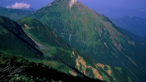
Norikura is a long ridge of small peaks rather than a single cone, with low green growth on its slopes cut by pale gullies and bands of loose rock. Morning light picks out every ridge and gully, and mist often drifts along the lower slopes. Snow covers the upper slopes from late autumn well into summer.

Scree gullies on the upper crest

From the Norikura plateau, the camera looks up at part of the summit crest in close-up. A pointed peak rises in the middle, with a smaller one on the left and a rounded, pale summit to the right. Low green growth covers the slopes, cut by pale gullies and bands of loose rock, and the morning light picks out every ridge. Mist sometimes drifts along the lower slopes.

Norikura, 3,026 m, is a line of small volcanoes along one ridge rather than a single cone, and it has been quiet for about two thousand years. Snow covers these slopes from late autumn well into summer.

The road to 2,700 metres

The Norikura Skyline from the Gifu side and the Echo Line from Nagano meet at Tatamidaira, at 2,702 m — the highest point reached by a paved road anywhere in Japan. Private cars have been banned since 2003; the only way up is by bus, taxi or bicycle, which has made the climb a fixture for cyclists. The snow walls at the top survive into June, and there is spring skiing above the bus stop. Near the summit the University of Tokyo runs the Norikura Observatory, a cosmic ray station that is the highest permanently staffed laboratory in the country. The volcano itself has been quiet for a long time: the last eruption was around two thousand years ago.

When to watch Norikura

The roads open at the end of May or in June and close in late October, and those months give the busiest, clearest views. Winter mornings are often sharp and completely empty. Japan is nine hours ahead of UTC.

Around Norikura

The Norikura plateau has hot springs, the Zengorō falls and a network of easy walking trails. Kamikōchi, the valley below Yakedake, and the old post town of Hirayu are both close.

Visiting Norikura

Buses run to Tatamidaira in season, from Hirayu on the Gifu side and from Norikura Kōgen in Nagano. From the car park the summit of Kengamine is about ninety minutes on foot.
Volcano cams near Mount Norikura

Mount Norikura on the map

Mount Aso, Kumamoto, JapanAsoMount Fuji, Shizuoka and Yamanashi, JapanFujiMount Asama, Nagano and Gunma, JapanAsamaKirishima (Shinmoedake), Kagoshima and Miyazaki, JapanKirishimaKusatsu-Shirane, Gunma, JapanKusatsu-ShiraneMount Unzen, Nagasaki, JapanUnzenMount Tokachi, Hokkaido, JapanTokachiMount Iwate, Iwate, JapanIwateMount Hakkōda, Aomori, JapanHakkōdaMount Adatara, Fukushima, JapanAdataraMount Komagatake, Hokkaido, JapanKomagatakeMount Esan, Hokkaido, JapanEsanMount Zaō, Yamagata and Miyagi, JapanZaōMount Usu, Hokkaido, JapanUsuMount Bandai, Fukushima, JapanBandaiTaisetsuzan, Hokkaido, JapanTaisetsuzanKuttara, Hokkaido, JapanKuttaraAogashima, Izu Islands, Tokyo, JapanAogashimaMount Meakan, Hokkaido, JapanMeakanSatsuma-Iōjima, Kagoshima, JapanSatsuma-IōjimaAkita-Yakeyama, Akita, JapanAkita-YakeyamaAtosanupuri, Hokkaido, JapanAtosanupuriMount Chōkai, Akita and Yamagata, JapanChōkaiHachijōjima, Izu Islands, Tokyo, JapanHachijōjimaKuchinoerabujima, Kagoshima, JapanKuchinoerabujimaMount Kurikoma, Iwate, Miyagi and Akita, JapanKurikomaNakanoshima, Tokara Islands, Kagoshima, JapanNakanoshimaMount Nasu, Tochigi, JapanNasuMount Azuma, Fukushima, JapanAzumaMount Hakone, Kanagawa, JapanHakoneMount Haku, Ishikawa, JapanHakuMount Iwaki, Aomori, JapanIwakiIzu Ōshima, Tokyo, JapanIzu ŌshimaIzu-Tōbu, Shizuoka, JapanIzu-TōbuKōzushima, Tokyo, JapanKōzushimaMount Kujū, Oita, JapanKujūNiigata-Yakeyama, Niigata, JapanNiigata-YakeyamaNiijima, Tokyo, JapanNiijimaMount Nikkō-Shirane, Tochigi, JapanNikkō-ShiraneMount Norikura, Nagano, JapanNorikuraMount Ontake, Nagano, JapanOntakeMount Tarumae, Hokkaido, JapanTarumaeLake Towada, Aomori, JapanLake TowadaMount Tsurumi, Oita, JapanTsurumiSakurajima, Kagoshima, JapanSakurajimaSuwanosejima, Kagoshima (Tokara Islands), JapanSuwanosejima

More volcano cams in Japan