

Nature Live Cams

Mount Kujū live cams

No recent report Volcanic complex in Oita, Japan

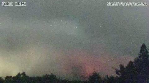
Live image of Mount Kujū: Iida Ōhara

Iida Ōhara

Source: Japan Meteorological Agency (JMA)

The range in profile from Iida, at its best in the last hour of daylight. What you see

Mount Kujū is a cluster rather than a single cone: sixteen lava domes, five stratovolcanoes and one basaltic cone packed into the middle of Kyushu, northeast of Aso caldera. Its summit, Nakadake, is 1,791 m (5,876 ft) and the highest point on the island of Kyushu. Activity has been migrating steadily eastward across the group for the last five thousand years.

Mount Kujū right now

Activity

No recent report

No automatic alert feed for this volcano. The observatory links below carry the latest reports.

Local time

–

Sunrise at 6:37 am, in 4 h 29 min.

Clouds over the summit

Overcast

100% cloud cover. Clearest in the next 24 hours: around 5:00 pm (2%).

At the summit

5 °C (41 °F)

Wind 21 km/h (13 mph) from the NW.

Forecast model values for the summit area from MET Norway, updated 17:02 UTC. Not a measurement.

Is Mount Kujū erupting right now?

No eruption reported. Nothing has been reported for it in recent weekly volcanic activity reports from the Smithsonian and USGS. Checked November 5, 17:02 UTC.

When did Mount Kujū last erupt?

Last eruption: 1996.

Earthquakes near Mount Kujū

No earthquakes large enough to appear in the international catalogue have been recorded within 30 km (19 mi) of the summit in the last 30 days.

Source: EMSC. Updated November 5, 16:32 UTC. EMSC combines the catalogues of national seismic networks, but it mostly lists earthquakes large enough to be reported internationally; many small volcanic earthquakes are not included. Small earthquakes are common under active volcanoes and do not by themselves mean an eruption is coming.

What you can see on the Kujū cams

Kujū is a cluster of rounded peaks and ridges rather than a single cone, rising above grassland and woods in the middle of Kyushu. The thing to look for is the steam from the vents that opened on Hosshōzan in 1995, a thin white plume that shows best on cold, clear mornings. Close to the vents the ground is bare scree and grey rock, and in the last hour of daylight the ridgeline stands out dark against the sky.

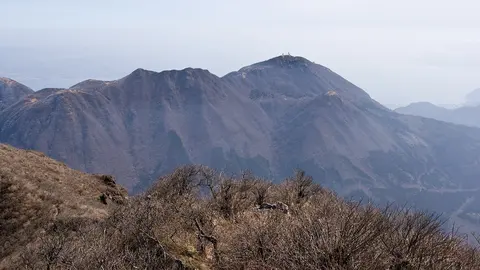
The range in profile from Iida

From Iida Ōhara the range lines up along the bottom of the picture as a row of peaks, from a lower rounded top on the left through several higher summits in the middle to a long ridge that fades out on the right. Closer, darker hills fill the foreground, and the top of a lattice tower pokes up at the bottom centre.

Seen side on and from further away than the other two cameras, the peaks stand out one behind another against the sky. Among them is Nakadake, at 1,791 m the highest point on Kyushu.

The Kujū summits over the Ueno woods

From Ueno the camera looks over a line of trees at the range: two big rounded peaks on the left, one behind the other, then a lower saddle and a long ridge with several tops running off to the right. Taller conifers stand at the right edge, close to the camera.

This is the widest of the three Kujū views and the one that shows how the summits line up. On clear days the steam from the vents that opened on Hosshōzan in 1995 can be seen from here as a thin white plume.

Bare scree and rock close to the 1995 vents

High on the northern ridge of Hosshōzan, this camera sits on a slope of loose, reddish scree that fills the right side of the frame. Beyond it, a bowl of bare grey rock and gravel opens out, crossed low on the left by pale lines that look like tracks, and a jagged ridge closes the skyline. There is almost no vegetation in sight.

The vents that opened in a steam explosion in October 1995 are close by, and their fumarole has been venting ever since.

The vent that opened in 1995

In October 1995 a steam explosion tore a new set of vents into the flank of Hosshōzan, the first eruption here since the eighteenth century. It threw ash over the hiking trails and left behind a fumarole that has been venting ever since, loudly enough to be heard from the path. That plume is now a permanent feature of the view and the thing the cameras are really watching. The last magma reached the surface about 1,600 years ago, when the Kurodake dome grew at the eastern end of the complex.

When to watch Kujū

The plume shows best on cold, clear mornings. Early June turns the upper slopes pink with Kyushu azaleas, and late October brings autumn colour to the moorland. Japan is nine hours ahead of UTC.

Around Kujū

The Tadewara and Bōgatsuru marshes at the foot of the range are protected wetlands on the Ramsar list, rare at this altitude in Japan. Kujū sits inside Aso-Kujū National Park, with the hot springs of Chōjabaru and Makinoto Pass nearby.

Visiting Kujū

The usual start is Makinoto Pass, with a path to Nakadake in about three hours return. The trails near the Hosshōzan vents are rerouted or closed whenever gas readings rise.
Volcano cams near Mount Kujū

Mount Kujū on the map

Mount Aso, Kumamoto, JapanAsoMount Fuji, Shizuoka and Yamanashi, JapanFujiMount Asama, Nagano and Gunma, JapanAsamaKirishima (Shinmoedake), Kagoshima and Miyazaki, JapanKirishimaKusatsu-Shirane, Gunma, JapanKusatsu-ShiraneMount Unzen, Nagasaki, JapanUnzenMount Tokachi, Hokkaido, JapanTokachiMount Iwate, Iwate, JapanIwateMount Hakkōda, Aomori, JapanHakkōdaMount Adatara, Fukushima, JapanAdataraMount Komagatake, Hokkaido, JapanKomagatakeMount Esan, Hokkaido, JapanEsanMount Zaō, Yamagata and Miyagi, JapanZaōMount Usu, Hokkaido, JapanUsuMount Bandai, Fukushima, JapanBandaiTaisetsuzan, Hokkaido, JapanTaisetsuzanKuttara, Hokkaido, JapanKuttaraAogashima, Izu Islands, Tokyo, JapanAogashimaMount Meakan, Hokkaido, JapanMeakanSatsuma-Iōjima, Kagoshima, JapanSatsuma-IōjimaAkita-Yakeyama, Akita, JapanAkita-YakeyamaAtosanupuri, Hokkaido, JapanAtosanupuriMount Chōkai, Akita and Yamagata, JapanChōkaiHachijōjima, Izu Islands, Tokyo, JapanHachijōjimaKuchinoerabujima, Kagoshima, JapanKuchinoerabujimaMount Kurikoma, Iwate, Miyagi and Akita, JapanKurikomaNakanoshima, Tokara Islands, Kagoshima, JapanNakanoshimaMount Nasu, Tochigi, JapanNasuMount Azuma, Fukushima, JapanAzumaMount Hakone, Kanagawa, JapanHakoneMount Haku, Ishikawa, JapanHakuMount Iwaki, Aomori, JapanIwakiIzu Ōshima, Tokyo, JapanIzu ŌshimaIzu-Tōbu, Shizuoka, JapanIzu-TōbuKōzushima, Tokyo, JapanKōzushimaMount Kujū, Oita, JapanKujūNiigata-Yakeyama, Niigata, JapanNiigata-YakeyamaNiijima, Tokyo, JapanNiijimaMount Nikkō-Shirane, Tochigi, JapanNikkō-ShiraneMount Norikura, Nagano, JapanNorikuraMount Ontake, Nagano, JapanOntakeMount Tarumae, Hokkaido, JapanTarumaeLake Towada, Aomori, JapanLake TowadaMount Tsurumi, Oita, JapanTsurumiSakurajima, Kagoshima, JapanSakurajimaSuwanosejima, Kagoshima (Tokara Islands), JapanSuwanosejima

More volcano cams in Japan