What you can see on the Aso cams
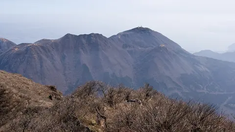
Aso's views take in a huge caldera of grassland, fields and villages, with the central peaks on the skyline and the plume of Nakadake rising above them. On calm days the plume goes straight up, and after heavy rain it can grow much larger; white means mostly steam, while grey or brown means ash. Horses graze on Kusasenri, the wide grassy plain below the central peaks.
From the Kusasenri meadow round to the steaming crater
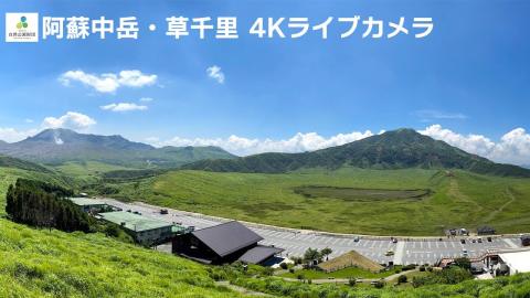
Set on a grassy slope above the Kusasenri car park, this camera turns slowly between two views. At one end of its sweep is the broad meadow of Kusasenri, with its shallow pond basin, the roofs of the visitor buildings and the road below, and a dark, rounded peak rising behind. At the other, the frame swings across the grassland and lower ridges to the skyline where the Nakadake crater sits, and where its white plume rises above the ridge.
The livestream is in 4K and comes from the foundation that runs the park. Horses graze on Kusasenri, and the parked cars give a sense of scale.
Nakadake's plume above the central peaks
Looking from Kusasenri towards the central cones, this view puts the long summit ridge across the lower third of the frame. The crater of Nakadake lies behind a lower ridge on the left, where its plume of steam and gas rises against the sky. Grass slopes darken the foreground, and the caption 阿蘇山(草千里) sits in the top left corner.
Unlike the livestream nearby, which turns, this still always holds the same frame, so it is the easier one for comparing the size and colour of the plume from one image to the next. A white plume is mostly steam; grey or brown means ash.
A line of Aso peaks against the morning sun
The camera at Kurumagaeri looks at a row of Aso's peaks spread across the bottom of the frame: a lower summit on the left, a broad double-topped mountain left of centre and another rounded top to the right, with the ridge falling away at the right edge. The rest of the picture is open sky.
In the morning the sun stands above the mountains in this view, so they show as a dark outline with glare and lens flare around them; the slopes come out with colour and detail later in the day. The outline itself is useful: a plume or ash cloud standing above the ridge shows clearly against the bright sky.
Across the southern valley to the line of peaks
From Minamiaso, in the southern valley inside the great caldera, this camera looks over fields and scattered houses to a long line of peaks on the skyline. A tree stands out against the lower slopes on the right and a bank of foliage edges the left corner; above the ridge there is a wide stretch of sky, which leaves plenty of room to see a plume.
Aso's caldera is one of the largest in the world, about 25 km from north to south, and tens of thousands of people live and farm inside it. That is the setting this view shows best: the volcano as a neighbour rather than as a crater.
Eruptions of Aso
Nakadake erupts every few years, usually with explosions of ash and steam. The most recent significant one, in October 2021, sent a pyroclastic flow more than 1 km (0.6 mi) down its flank. Its crater lake, a milky turquoise pool, appears and disappears depending on how hot the crater is.
When to watch Aso
Mornings in spring and autumn usually bring the clearest skies. After heavy rain the plume from Nakadake often grows, which makes for a dramatic view even when nothing is erupting. Japan is nine hours ahead of UTC.
Around Aso
Daikanbo, on the northern rim of the caldera, gives the best overall view of the five peaks inside it and of the farmland on the caldera floor. Aso Shrine, one of the oldest in Japan, was badly damaged in the 2016 Kumamoto earthquakes and has since been restored. The hot spring village of Kurokawa Onsen lies a short drive to the north.
Visiting Aso
When volcanic gas levels and the alert level allow, visitors can drive or hike up to the edge of Nakadake’s crater and look into it, one of the few places in the world where that is possible. The crater area closes often, sometimes at short notice, so check the local information before going.