Nature Live Cams

Kuchinoerabujima live cams

No recent report Stratovolcano in Kagoshima, Japan

Live image of Kuchinoerabujima: From Yakushima, across the strait

From Yakushima, across the strait

Source: Japan Meteorological Agency (JMA)

From the neighbouring island, which is the safe distance: the whole of Kuchinoerabu in one frame.

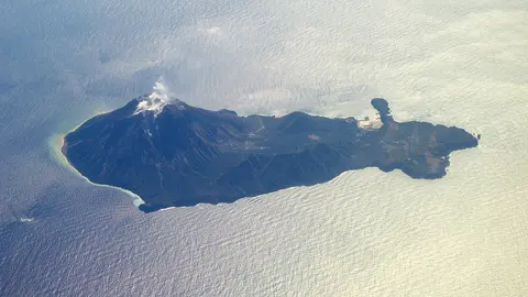
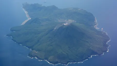
Kuchinoerabujima is a small island west of Yakushima with about a hundred people on it and a volcano, Furudake, at 657 metres. In May 2015 it erupted hard enough to send a pyroclastic flow down to the sea, and every single resident was taken off the island.

Kuchinoerabujima right now

Activity

No recent report

No automatic alert feed for this volcano. The observatory links below carry the latest reports.

Local time

–

Sunrise at 6:37 am, in 4 h 45 min.

Clouds over the summit

Mostly clear

20% cloud cover.

At the summit

19 °C (66 °F)

Wind 43 km/h (27 mph) from the NW.

Forecast model values for the summit area from MET Norway, updated 16:32 UTC. Not a measurement.

Is Kuchinoerabujima erupting right now?

No eruption reported. Nothing has been reported for it in recent weekly volcanic activity reports from the Smithsonian and USGS. Checked November 5, 16:32 UTC.

Earthquakes near Kuchinoerabujima

No earthquakes large enough to appear in the international catalogue have been recorded within 30 km (19 mi) of the summit in the last 30 days.

Source: EMSC. Updated November 5, 16:02 UTC. EMSC combines the catalogues of national seismic networks, but it mostly lists earthquakes large enough to be reported internationally; many small volcanic earthquakes are not included. Small earthquakes are common under active volcanoes and do not by themselves mean an eruption is coming.

What you can see on the Kuchinoerabujima cams

Kuchinoerabujima is a small, green island with a line of rounded summits at its centre, and a plume of steam or ash above that ridge is the sign to look for. This is one of the wettest corners of Japan, so cloud often hides the top; winter and early spring give the clearest days.

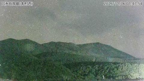
The summit ridge seen from Honmura

Above the main village of Honmura, on the west side of the island, the camera looks up at the volcano's summit ridge. A line of rounded tops runs across the skyline, the highest on the left, with a lower forested ridge and dark trees filling the middle and foreground. A thin strip of water shows at the bottom edge. A timestamp and the caption 口永良部島(本村西), west of Honmura, run along the top.

In the morning the camera faces into the light and the slopes go dark; they show more detail later in the day. In 2015 an eruption here sent a pyroclastic flow to the sea and the whole island was evacuated.

Evacuated, and then came back

The 2015 eruption gave very little warning. The flow reached the coast within minutes and the island was cleared the same day; nobody was killed. Most residents were away for months, and some for much longer, before the alert level came down enough to go home. The volcano erupted again in 2018 and 2019 and the pattern has repeated on a smaller scale since. Living there now means living with an alert level that moves, a designated shelter and a ferry that is also the evacuation route.

When to watch Kuchinoerabujima

Japan is nine hours ahead of UTC all year. This is a subtropical, very wet corner of the country — Yakushima next door is famous for raining most days — so clear frames are the exception. Winter and early spring are the driest; typhoons pass through between July and October.

Around Kuchinoerabujima

Yakushima, twelve kilometres east, is a UNESCO World Heritage site for its ancient cedar forest and is where the ferry comes from. Both islands are part of the Kirishima-Yaku National Park, and the Ōsumi Islands stretch north from here towards Kagoshima.

Visiting Kuchinoerabujima

A ferry runs from Yakushima a few times a week and takes under two hours. There is a hot spring on the coast and very little else in the way of facilities. Access to the upper mountain depends entirely on the alert level and is often closed outright.
Volcano cams near Kuchinoerabujima

Kuchinoerabujima on the map

Mount Aso, Kumamoto, JapanAsoMount Fuji, Shizuoka and Yamanashi, JapanFujiMount Asama, Nagano and Gunma, JapanAsamaKirishima (Shinmoedake), Kagoshima and Miyazaki, JapanKirishimaKusatsu-Shirane, Gunma, JapanKusatsu-ShiraneMount Unzen, Nagasaki, JapanUnzenMount Tokachi, Hokkaido, JapanTokachiMount Iwate, Iwate, JapanIwateMount Hakkōda, Aomori, JapanHakkōdaMount Adatara, Fukushima, JapanAdataraMount Komagatake, Hokkaido, JapanKomagatakeMount Esan, Hokkaido, JapanEsanMount Zaō, Yamagata and Miyagi, JapanZaōMount Usu, Hokkaido, JapanUsuMount Bandai, Fukushima, JapanBandaiTaisetsuzan, Hokkaido, JapanTaisetsuzanKuttara, Hokkaido, JapanKuttaraAogashima, Izu Islands, Tokyo, JapanAogashimaMount Meakan, Hokkaido, JapanMeakanSatsuma-Iōjima, Kagoshima, JapanSatsuma-IōjimaAkita-Yakeyama, Akita, JapanAkita-YakeyamaAtosanupuri, Hokkaido, JapanAtosanupuriMount Chōkai, Akita and Yamagata, JapanChōkaiHachijōjima, Izu Islands, Tokyo, JapanHachijōjimaKuchinoerabujima, Kagoshima, JapanKuchinoerabujimaMount Kurikoma, Iwate, Miyagi and Akita, JapanKurikomaNakanoshima, Tokara Islands, Kagoshima, JapanNakanoshimaMount Nasu, Tochigi, JapanNasuMount Azuma, Fukushima, JapanAzumaMount Hakone, Kanagawa, JapanHakoneMount Haku, Ishikawa, JapanHakuMount Iwaki, Aomori, JapanIwakiIzu Ōshima, Tokyo, JapanIzu ŌshimaIzu-Tōbu, Shizuoka, JapanIzu-TōbuKōzushima, Tokyo, JapanKōzushimaMount Kujū, Oita, JapanKujūNiigata-Yakeyama, Niigata, JapanNiigata-YakeyamaNiijima, Tokyo, JapanNiijimaMount Nikkō-Shirane, Tochigi, JapanNikkō-ShiraneMount Norikura, Nagano, JapanNorikuraMount Ontake, Nagano, JapanOntakeMount Tarumae, Hokkaido, JapanTarumaeLake Towada, Aomori, JapanLake TowadaMount Tsurumi, Oita, JapanTsurumiSakurajima, Kagoshima, JapanSakurajimaSuwanosejima, Kagoshima (Tokara Islands), JapanSuwanosejima

More volcano cams in Japan